“Maps and their textual counterparts are complex documents, fraught with information from the most basic geographical facts to complex political and cultural details.” An account of Ancient Egypt across media.
Mapping Herodotus
In “Achilles’ Shield: Mapping the Ancient Cosmos,” an Interdisciplinary Seminar taught by professors Hallie Franks and Matthew Stanley, much of our coursework focused on how we communicate information, particularly scientific observations, through various mediums. Maps and their textual counterparts are complex documents, fraught with information from the most basic geographical facts to complex political and cultural details. The mediums we focused on in class, the textual and the visual, both have limitations. Following an assignment in which I converted Herodotus’ description of Egypt from The Histories from text to image, I wanted to explore how the translation process might be different when converting the description to sound. Around and after Herodotus’ time, some astronomers and philosophers began to explore music as a means of understanding the world. Based on the work of some of these figures, such as Ptolemy and Kepler, this project provides another perspective on how different mediums might facilitate the communication of geographical information.
Music was a large part of the culture in Herodotus’ classical Greece. Song was used in religious circumstances, for the telling of myths, and even for political reasons (Landels 12). Song and music were as prevalent in drama and poetry as the spoken word (9). While there was not necessarily a tradition of mapping more scientific or mathematically based information through sound at this point, the use of sound to communicate histories was quite common.
A bit later, certain figures, such as Ptolemy, began to explore the mathematics of sound and how that might connect to the movement of the celestial bodies. Ptolemy, known for his work concerning the celestial bodies in the Almagest, also wrote about sound and music in Harmonics. There, he identifies ratios between tones and discusses how to organize music through both empirical processes, such as listening, and modes of reason, such as math (Barker 25). This attempt to organize and understand music through harmony is likened to the process of organizing and understanding the universe through astronomy (266). Ptolemy describes the similarities between “hearing and sight” as understood by “arithmetic and geometry” (266) in understanding and ordering the physical world. This connection suggests that there is a common thread in how sound and image function, and which may facilitate translation between the two and from text.
This idea of translating a textual or scientific description of the universe into a musical representation appears later, during the renaissance. Kepler’s Harmonies of the World demonstrates how the mathematical components underpinning music theory can be used to represent scientific observations of the visual world. For Kepler, this meant representing the planets location by notes and movement by the range between the extreme notes that correspond with each planets movement. “Somehow” (Kepler 200) the modes have been distributed to the planets by way of the intervals that they traverse. The tonic has been to the slowest speed of each planets orbit, while the biggest interval is set between the tonic and the note representing the fastest orbit. Here, then, we see a systematic representation of the aphelial and perihelial movements of the planets through music. More generally, this is a sonic representation of the visual, achieved through corresponding numerical values.
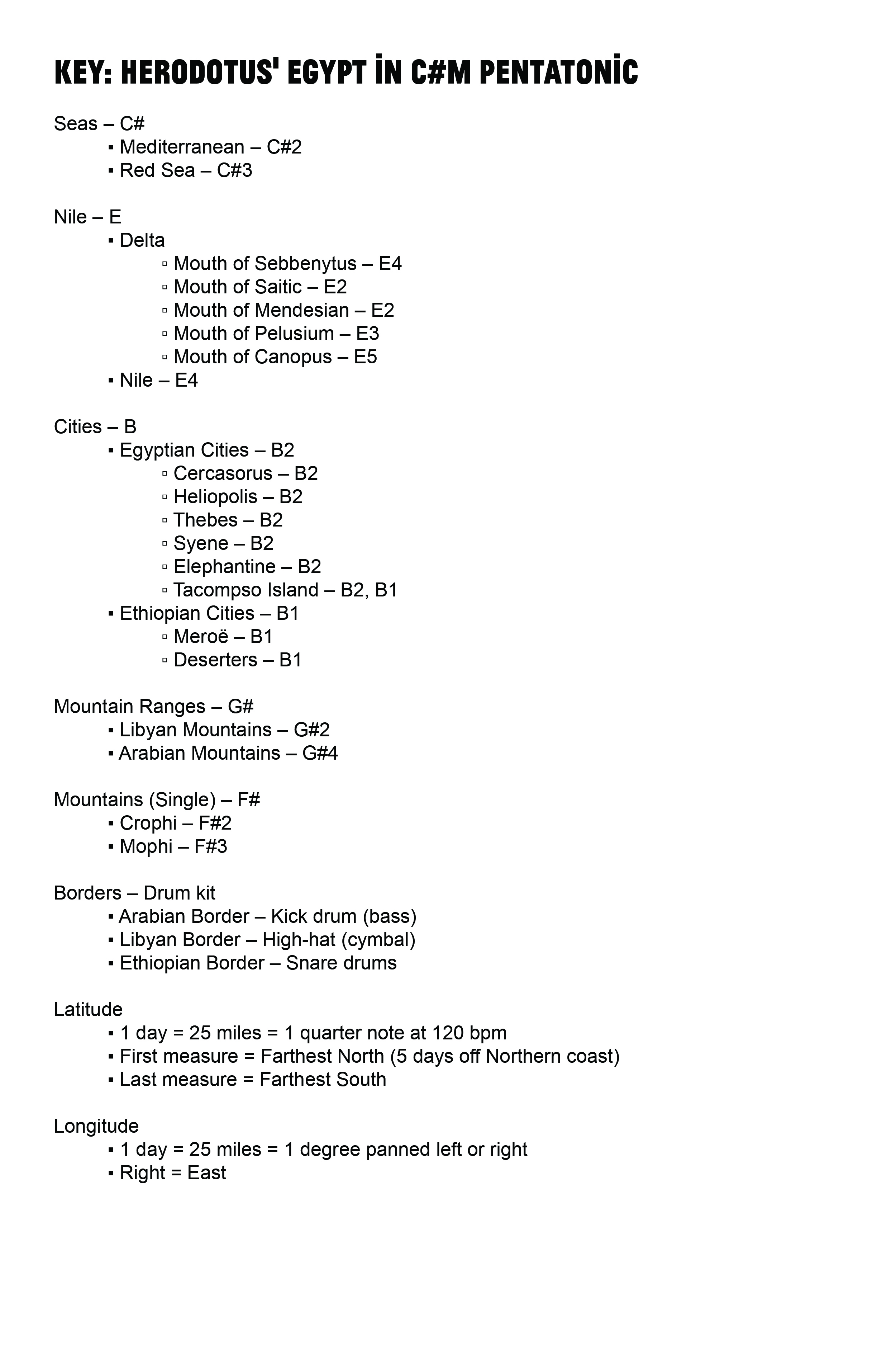
For this project, I created a work that has roots in the scientifically derived cosmological music of Kepler. However, I represent Herodotus’ textual geography instead of an observed cosmology. To achieve this, I initially took a systematic approach. In a similar way to how Kepler assigned tones to each planet, I assigned certain notes or types of sounds to certain features of the geography. I chose to work within the C#m pentatonic scale to limit the number of notes involved. I hoped it would be a bit easier to distinguish between only five notes and three distinct drum sounds when listening to the final product. Each note of the scale was assigned to an element of the geography based a careful interpretation of Herodotus’ work. Subcategories were then differentiated by the octave of the note assigned to the geographical element (denoted by the number next to the note name in Figure 1). I chose not to break down each distance numerically with corresponding tones based on frequency (in Hz), though to do so might have been closer to Kepler’s process. By assigning notes in a specific limited scale I hoped to make the information contained in the piece a bit more accessible through listening alone.
Representing the distances from east to west and north to south was a bit more complicated. Kepler’s works represent repetitive motion in a simple elliptical pattern through movement from an extreme note to another. The temporal aspect inherent in the sonic medium is attached to the movement of the orbit (Kepler 199). In representing movement in my sonic map, I chose to represent movement along the Nile through the passing of time. Since the Nile runs roughly north-south the temporal element came to represent latitude. For my purposes a quarter note at 120 beats per minute represents one day, or roughly 25 miles. The east-west distances were then plotted through panning. Panning is a feature in stereo sound recordings where a sound can be moved to a greater degree into the right or left speaker. Thus, the sounds in the right speaker can represent elements in the east, while sounds farther to the left may represent sounds to the west. For my purposes, one degree panned left or right represents one day, or roughly 25 miles. Once these properties were established it was just a matter of plotting the information presented in the Herodotus’ description of Egypt to the best of my ability.
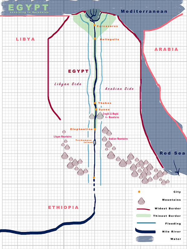
This process of transformation from one medium to another began with my attempt to map Herodotus’ literary description of Egypt as a visual map. In process, some challenges emerged. Despite the careful mathematical connections Ptolemy and Kepler make between the sonic and visual, many of these challenges were due to fundamental differences between the textual, visual, and sonic mediums. The information presented by Herodotus was often limited to personal knowledge or sketchy second-hand descriptions, particularly below Elephantine (Herodotus 95). Much of the information presented about distance and time was also from personal observation and accounts. For example, Herodotus claims that the Nile continues for four months from Elephantine to Deserters based on second-hand information. This span of time is likely affected by myriad other factors, from weather to the Nile’s currents to the time of year. This makes it difficult to be sure if any of these temporal and distance measurements are reliable or comparable. When translating to image or sound there is a tendency to represent information like this in a regular spatial or temporal grid. However, the textual information might not fit into this strict format if the original measurements are not standardized.
This grid issue is particularly problematic in the sonic medium. Listening to even this fairly simplified representation of Egypt can be confusing at times. Sound is not the clearest medium through with to communicate usable, originally visual or textual information. As everything is described in relation to the Nile, it becomes easier to use that as the temporal and roughly latitudinal axis of the sonic interpretation. However, despite the lack of information about the shape of the Nile in the text, we know that the Nile does curve. Therefore, this roughly grid-like sonic interpretation is perhaps not the most effective way to represent the geography. Nonetheless, were information about the curves of the Nile included, and were the Nile to sonically wave from left the right (east to west) along this roughly-gridded sonic plane, the relative distances of other elements, such as the length of the coastline as opposed to the location of the Arabian and Libyan Mountains, would become even more difficult to decipher from just listening. It seems that in some ways, then, simplification might be helpful in making the information presented in the sound piece clearer, despite inaccuracy. The way Herodotus’ presents the information, therefore, necessitates a sonic structure in which the Nile is central.
These translation problems, and the more scientific methods of Ptolemy and Kepler, demonstrate that translation involves complications and compromises. Perhaps it is easier to achieve an accurate translation if there is greater emphasis on the rational ordering of information in both the original textual medium and the subsequent sonic representation. However, in absence of this attention to detail, leaving room for interpretation and simplification can facilitate the legibility of the finished sonic map. When it comes to sound, Ptolemy might have had the right idea in considering both empirical and rational modes of understanding. In moving from one medium to another, the translator must prioritize certain information. Ordering the universe through sound and image based on systematic, rational principals is still useful in creating new geographical documents. Sound, just like a visual map, still requires some textual labeling to render legible. However, the state of the original text greatly affects what can be done with the information in a new medium and how well, if at all, that new work will ultimately communicate the geography.
Works Cited
Barker, Andrew. Scientific Method in Ptolemy’s Harmonics. Cambridge: Cambridge UP, 2000. Print.
Herodotus, and John Marincola. “Book Two.” The Histories. Trans. Aubrey De Sélincourt. London: Penguin, 2003. 86-103. Print.
Kepler, Johannes, and Charles Glenn, Wallis. Epitome of Copernican Astronomy & Harmonies of the World ;. New York: Prometheus, 1995. 199-203. Print.
Landels, John G. Music in Ancient Greece and Rome. London: Routledge, 1999. Print.